


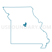
Lupus Voting District, Moniteau County, Missouri
About
Outline

Summary
| Unique Area Identifier | 609146 |
| Name | Lupus Voting District |
| County | Moniteau County |
| State | Missouri |
| Area (square miles) | 31.73 |
| Land Area (square miles) | 30.39 |
| Water Area (square miles) | 1.34 |
| % of Land Area | 95.78 |
| % of Water Area | 4.22 |
| Latitude of the Internal Point | 38.84048700 |
| Longtitude of the Internal Point | -92.47998900 |
Maps


Graphs
Select a template below for downloading or customizing gragh for Lupus Voting District, Moniteau County, Missouri


Neighbors
Neighoring Voting District (by Name) Neighboring Voting District on the Map
- Voting District 26, Boone County, MO
- Voting District 27, Boone County, MO
- Voting District 37, Boone County, MO
- Voting District 38, Boone County, MO
- Boonville Rural No. 1 Voting District, Cooper County, MO
- Jamestown Voting District, Moniteau County, MO
- Prairie Home Voting District, Cooper County, MO
Top 10 Neighboring County Subdivision (by Population) Neighboring County Subdivision on the Map
- Rock Bridge township, Boone County, MO (8,261)
- Three Creeks township, Boone County, MO (5,133)
- Katy township, Boone County, MO (3,787)
- Linn township, Moniteau County, MO (1,292)
- Saline township, Cooper County, MO (840)
- Prairie Home township, Cooper County, MO (682)
Top 10 Neighboring Place (by Population) Neighboring Place on the Map
Top 10 Neighboring Unified School District (by Population) Neighboring Unified School District on the Map
- Columbia Public Schools, MO (136,836)
- Boonville School District, MO (11,591)
- Moniteau County C-1 School District, MO (1,409)
- Prairie Home R-V School District, MO (1,387)
Top 10 Neighboring State Legislative District Lower Chamber (by Population) Neighboring State Legislative District Lower Chamber on the Map
Top 10 Neighboring State Legislative District Upper Chamber (by Population) Neighboring State Legislative District Upper Chamber on the Map
- State Senate District 19, MO (188,056)
- State Senate District 6, MO (181,242)
- State Senate District 21, MO (163,305)
Top 10 Neighboring 111th Congressional District (by Population) Neighboring 111th Congressional District on the Map
- Congressional District 6, MO (693,974)
- Congressional District 9, MO (684,101)
- Congressional District 4, MO (679,375)
Top 10 Neighboring Census Tract (by Population) Neighboring Census Tract on the Map
- Census Tract 18.05, Boone County, MO (9,020)
- Census Tract 17.02, Boone County, MO (4,306)
- Census Tract 3851, Moniteau County, MO (4,010)
- Census Tract 9501, Cooper County, MO (3,303)